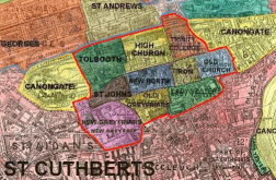
The ecclesiastical parishes within the City of Edinburgh.
 This map shows the 10 ecclesiastical parishes within the old city of Edinburgh in the early part of the 19th century; these formed the 'civil' parish of Edinburgh.
Births, deaths and marriages from all these parishes were collated and recorded in a single series of registers. This is what is often known as 'Edinburgh Parish' .
When the 'New Town' was built, a further 4 parishes were added; these new parishes of the new town were formerly part of St Cuthberts Parish.
See larger map
(the larger map shows the full area of the new Town)
The original old town of Edinburgh is enclosed by the red line.
It includes the parishes of:
Tolbooth, High Church, Trinity College, Old Church, Tron, New North, St Johns, Lady Yesters, Old Greyfriars, New Greyfriars.
The light blue line encloses the parishes of the 'New Town'
It includes the parishes of:
St Stephens, St Marys, St Georges, St Andrews.
(until the new town was built, this area was part of St Cuthberts).
St Cuthberts - This parish which almost surrounds Edinburgh, is also known as 'West Church Parish'
The printed map I've used to show the parish boundaries actually dates from the 1890's