Adamsrow, Squaretown and Redrow
 The villages of Adamsrow, Squaretown and Redrow in Newton parish were all small villages or hamlets mainly inhabited by miners. They were all very similar rows of small low roofed houses with red tiled roofs.
no trace of them exists now.
The site they formerly occupied eventually became the location of Monktonhall, one of the National Coal Boards 'super pits' built in the 1960's and closed in 1980s.
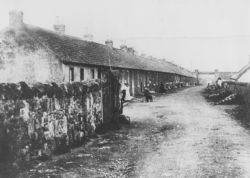
Photo of Adamsrow around 1900
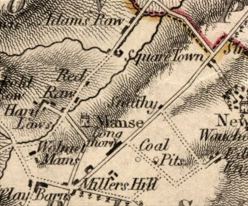
1747-55 Roy's Map of Scotland None of these villages existed at the time this map was compiled.
 |
1812 - Map of Edinburghshire  The areas has changed dramatically in 60 years, and all three villages are now shown although Redrow is still very small. The areas has changed dramatically in 60 years, and all three villages are now shown although Redrow is still very small. |
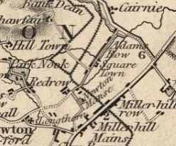
1820s Map  Redrow has expanded significantly by this time.
 |
1856 - Ordnance Survey  The recently built railway cutting through Adamsrow is shown here. The railway bridge is visible at the end of the street in the photo. The recently built railway cutting through Adamsrow is shown here. The railway bridge is visible at the end of the street in the photo. |
For more information on Adamsrow, see the website 'The Adams Family of Adamsrow'