The edge coals and flat coals

Simplified section though part of the coalfield
Edge coals
The most noticeable thing about the Midlothian coalfield are the 'edge coals' which got their name from the way the seams of coal come up to the surface at a very steep angle. They are found at the west side of the coalfield, and run in a southerly direction from the sea down through Niddry, Gilmerton and Loanhead.
Towards the eastern end of the coalfield, the seams slope towards the surface at a much shallower angle and of course were not known as 'edge seams'.
Flat coals
In this central part of the field, around Craighall, Dalkeith etc were a number of thick seams known as the 'flat coals' from their relatively flat angle. They include a number of very thick seams that were mined at places such as Craighall and, Sheriffhall.
Other coal seams
There were plenty of other coal seams outwith the two coalbearing groups mentioned above, however they were generally thin and uneconomical to mine.
Limit of the coalfield
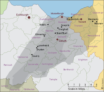
 This map shows the limit of the coalfield which extended into East Lothian and down into Peebleshire at it's southern extremity.
The parishes within the coalfield, along with some of the main collieries where members of the Hood family worked are shown here.
The family who were bound to the Dryden coalworks in the 18th century, seemed to prefer working in the same 'edge seams' when they were free to work elsewhere, so hardly went outside the parishes of Lasswade and Liberton until the 1780s